How to Use GPS for Land Surveying (and Pros & Cons)

6 Pros and Cons of Using GPS for Land Surveying
The Global Positioning System emerged in 1973 as an experimental project led by the Department of Defense. Few people could’ve predicted just how impactful this project would be and how ubiquitous GPS would become. It is an essential part of most surveys, and GPS devices are an essential piece of
hand held survey equipment. Still, there are both pros and cons associated with this technology — learn more about both.
1. Pro: Better Accuracy
One of the most commonly cited advantages of GPS technology is the incredible accuracy that it offers to surveyors. It’s true that no unit of measurement is quite as precise as GPS coordinates. Other surveying methods cannot match the exactness, so when precision is imperative, GPS is the way to go.
2. Con: Clear Skies Required
Although GPS can offer remarkably precise measurements, it may not be able to produce any measurements if the skies are not clear. GPS relies on communication between
survey equipment and satellites in space, so if there are any clouds or inclement weather, this communication may be impeded.
3. Pro: Calculations Are Quick
Accuracy and precision are the most important aspects of surveying, but the value of efficiency must be considered, too. This is one of the most important advantages that GPS can offer — it calculates measurements quickly, saving surveyors a lot of time in the process. The measurements that a GPS device can generate in a few moments could take a surveyor hours to complete manually.
4. Con: Interference Can Occur
Surveyors must also account for the possibility of interference when using GPS
survey instruments. Trees, tall buildings, and other obstructions can easily thwart a device’s signal and prohibit readings. In some cases, moving to a new position may mitigate the problem, but sometimes a device may not be able to connect at all if the interference is substantial.
5. Pro: Wireless Data Delivery
If there is no interference, surveyors can enjoy yet another benefit of GPS devices — the ability to transmit data wirelessly. This allows for the real-time delivery of information and communication with other devices. If a surveyor needs to send data to a developer, for example, wireless delivery means that they can do so without assistance from any other device.
6. Con: GPS Tools Can Be Costly
One of the greatest drawbacks of GPS devices is the high price point that many of them come with. While GPS is more accurate and convenient than other kinds of surveying equipment, these benefits are costly. Surveyors should consider whether the potential expense of a GPS device is worth the time and money it may save in the long run.
Find Hand Held Survey Equipment With Built-In GPS
GPS is a great tool for surveyors who need efficient and accurate measurements. If you’re planning on investing in this type of
hand held survey equipment, though, you should also keep backup equipment on hand in case of interference or inclement weather. Find GPS devices and every other type of
survey tools at Engineer Supply. Call us at (800) 591-8907 to start your next order.

Frequently Asked Questions
How do GPS survey devices work?
GPS survey devices work by connecting to the satellites in the Global Positioning System with an internal antenna. The antenna communicates with the satellites to generate a unique signal, and this signal generates an exact set of coordinates indicating a location.
What do surveyors use GPS hand held survey equipment for?
Surveyors use GPS equipment for a range of surveying tasks, but it’s most commonly used to create highly accurate maps. GPS devices can be placed at multiple points across a property in order to measure distances and determine the exact location of specific features of the property.
What are the four most common methods of GPS surveying?
There are four methods of GPS surveying most commonly used — static, fast-static, kinematic, and OPUS. Static surveying is used to identify baselines between GPS devices. Fast-static is used for this same purpose, but its observation period is abbreviated. Kinematic produces real-time measurements with a stop-and-go measurement technique. OPUS is the Online Positioning User Service, and it relies on individual users to submit GPS data to the National Geodetic Survey.
Is GPS the most accurate kind of hand held survey equipment?
Yes, GPS is typically considered the most accurate option for surveying devices.
What kind of survey measurements can a GPS device produce?
GPS devices can be used to produce nearly any kind of measurement, including distance, angles, and slopes. It is most commonly used for measuring distance, though.
Best Survey Equipment
Magnetic Locators
If you’re looking for lot lines in an urban or suburban area, there are likely already surveying stakes in the corners of every lot. It’s important to mark your own lines to verify accuracy, but a convenient place to start is with the existing surveying stakes.
A magnetic locator helps you find these stakes. Simply turn on the locator and work your way around the area where a stake is likely buried. These locators detect magnetic signals from buried metal items, so they’ll find a number of other items in addition to surveying stakes. Once you find a metallic object, dig it out to verify it’s a stake.
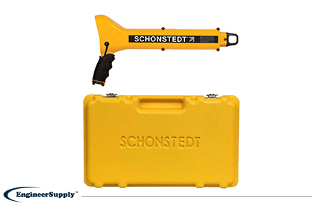
One of the most convenient, practical locators is the
Schonstedt GA-52Cx. This basic model is highly reliable, but doesn’t have all the programmable settings of other locators. Use it to find metallic objects with highly sensitive location technology and a rugged, weather-resistant control panel.
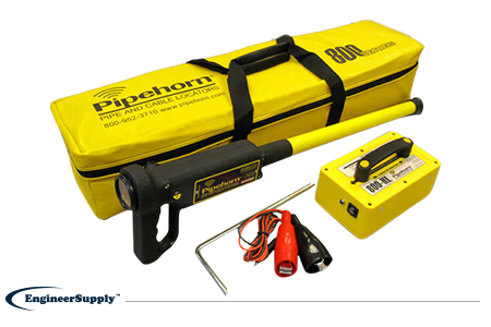
The
Pipehorn 800HL detector is one of the most versatile options for locating buried objects. This dual-frequency detector works as both a pipe and cable locator. Connect the transmitter to a buried line to follow an electric, water or gas line buried in the ground. Once you locate and flag these buried lines, switch modes to sweep for unmarked utilities with the tracer wire and tape.
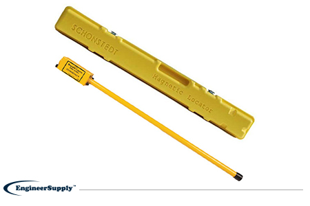
A more portable, high-tech Schonstedt magnetic locator option is the
GA-92XTd. This model uses a compact design and versatile control panel for both audio and visual indication. The small size doesn’t mean less power, so you can use this locator to find ferrous items buried up to 16 feet underground. Pack it away in the small, durable case to keep in your truck or toolbag wherever you work.