5 Easy Steps To Reading Survey Coordinates | Engineer Supply - EngineerSupply

800.591.8907 M-F 8-5PM EST

21 Years Serving Customers Like You. Buy With Confidence.

How to Read Survey Coordinates

How-To-Read-Survey-Coordinates-HDR

5 Easy Steps To Reading Survey Coordinates

Whether you’re new to the field of surveying or attempting to conduct a DIY survey on your own property, understanding survey coordinates is one of the first skills you must learn. Indeed, there are many survey instruments that can help you record coordinates, but if you don’t know how to read them, you won’t be able to do much with your data. Consider the following five steps to understanding these numbers and interpreting them correctly.

1.­­­ Identifying the Cardinal Direction

How-To-Read-Survey-Coordinates-SI-1 Coordinates will typically include both numbers and letters. The numbers indicate three units of measurement — degrees, minutes, and seconds — while the letters indicate the cardinal direction of the measurement. Coordinates that say E 29° 04' 05" E, for example, would represent a measurement that is 29 degrees, 4 minutes, 5 seconds from the east to the west. Surveyors thus must understand the four cardinal directions — north, south, east, and west — and understand how to find each.

2.­­­ Identifying the North Direction

How-To-Read-Survey-Coordinates-SI-2 The most important cardinal direction is north. It is prioritized because it is typically the easiest to find — you can simply look to the sky and find Polaris, or the North Star. This will help you gain your bearings and identify the position of east, west, and south, too. Of course, the easiest and most accurate way to identify these directions is by using a compass.

3.­­­ Determining Where the Land Is Located From the Corner Point

How-To-Read-Survey-Coordinates-SI-3 Once you’ve figured out how to identify the cardinal directions on your survey site, you can proceed to determine where the land is located from the corner point. To do this, you must first identify one of the corners of the property. Identifying boundary lines is often challenging, but you can refer to any prior surveys or legal documents that may make this task easier. These documents will likely contain coordinates indicating their location. Once you’ve located one of the property’s corners, mark it with a flag or marking whiskers.

4.­­­ Following a Line To Find Another Corner

How-To-Read-Survey-Coordinates-SI-4 Repeat the previous step to locate another corner of the property. Look at the coordinates listed on the property’s deed or previous survey, and follow the line to the next corner. Mark it, too, with a flag or marking whiskers.

5.­­­ Confirming Your Work With a Reciprocal Bearing

How-To-Read-Survey-Coordinates-SI-5 You should repeat these steps until every corner of the property is marked according to the coordinates, and then you should confirm your work by establishing a reciprocal bearing. A reciprocal bearing refers to two coordinates that are positioned in opposition, 180° apart. To determine the reciprocal bearing of your coordinates, add or subtract 180° and confirm that the result is the inverse of your original measurements.

Understand How to Decipher Survey Coordinates

Understanding survey coordinates is an important ability for amateur and professional surveyors alike. It can certainly take some practice, but with the right survey equipment, you’ll be able to get the hang of it. Engineer Supply has the survey tools and accessories you need. Call us at (800) 591-8907 to ask questions or start your order.

Shop Survey Equipment

Frequently Asked Questions

How do I find survey coordinates on a map?

How-To-Read-Survey-Coordinates-A

If you are looking at a survey map, its coordinates may be located in several places. Sometimes a surveyor will mark coordinates directly adjacent to the feature that they are measuring — for example, when identifying a topographical feature, its survey coordinates may be marked directly on the plat.

Do surveyors use coordinates with GPS?

Yes, surveyors often use GPS to produce coordinates. A plat or map is more likely to use specialized survey coordinates, though, rather than a property’s GPS coordinates. In some cases, a surveyor may record both.

Can I convert survey coordinates to GPS coordinates?

Converting survey coordinates to GPS coordinates can be tricky, but there are some online programs that allow you to do so. You will need to know the geographical location of the property in order to find it and pinpoint the location of the original survey coordinates.

Why do surveyors use special kinds of coordinates?

Surveyors use a unique system of coordinates because they must track several different kinds of measurements. Rather than simply noting distance, for example, a surveyor must document slope, angles, and elevation, too.

What are the degrees, minutes, and seconds in survey coordinates?

How-To-Read-Survey-Coordinates-B

One of the unique features of survey coordinates is their unit of measurement — degrees, minutes, and seconds — which denotes highly precise angles. This form of measurement allows surveyors to calculate measurements based on the circular position of the cardinal directions.


Best Survey Equipment

Magnetic Locators

If you’re looking for lot lines in an urban or suburban area, there are likely already surveying stakes in the corners of every lot. It’s important to mark your own lines to verify accuracy, but a convenient place to start is with the existing surveying stakes.

A magnetic locator helps you find these stakes. Simply turn on the locator and work your way around the area where a stake is likely buried. These locators detect magnetic signals from buried metal items, so they’ll find a number of other items in addition to surveying stakes. Once you find a metallic object, dig it out to verify it’s a stake.
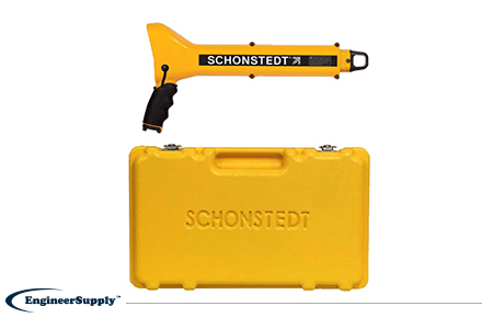
One of the most convenient, practical locators is the Schonstedt GA-52Cx. This basic model is highly reliable, but doesn’t have all the programmable settings of other locators. Use it to find metallic objects with highly sensitive location technology and a rugged, weather-resistant control panel.
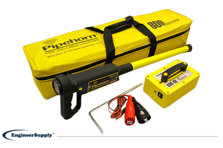
best-survey-equipment-GA-52Cx

The Pipehorn 800HL detector is one of the most versatile options for locating buried objects. This dual-frequency detector works as both a pipe and cable locator. Connect the transmitter to a buried line to follow an electric, water or gas line buried in the ground. Once you locate and flag these buried lines, switch modes to sweep for unmarked utilities with the tracer wire and tape.

best-survey-equipment-MD840

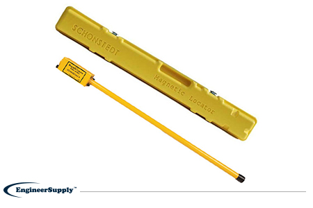
A more portable, high-tech Schonstedt magnetic locator option is the GA-92XTd. This model uses a compact design and versatile control panel for both audio and visual indication. The small size doesn’t mean less power, so you can use this locator to find ferrous items buried up to 16 feet underground. Pack it away in the small, durable case to keep in your truck or toolbag wherever you work.

best-survey-equipment-GA-92XTd

Please Wait... processing