Professional Land Surveyor | Why it is Important to Hire a Pro

The Importance of Hiring a Professional Land Surveyor
When it comes to land development, nothing can move forward until a land survey is complete. The entire project area needs to be mapped to identify landforms, potential risks, boundaries and the plans for the job. A successful, safe project must begin with accurate information, which is why it’s important to hire a professional land surveyor to do the work. The report issued by the surveyor becomes the foundation of everything that follows for either development or construction. A professional receives the most accurate information through training, experience and equipment made by industry leaders like
SitePro.

Tasks for a Professional Land Surveyor
Development projects require a lot of work, but everything is on hold until a land surveyor can assess the land and make the proper reports. There are several options a surveyor may pursue when determining all the essential information needed to start a project.
Boundary Surveys
The most accurate and complete survey used to establish boundary lines for industrial, commercial or residential properties is the boundary survey. In addition to looking at the physical stakes or markers that are in the ground and conducting field observations, the surveyor works with data from independent research and various calculations to determine where the boundary lines are for a specific property and any adjoining properties.
Topographical Surveys
In addition to knowing where the boundary lines are, project developers need to know about potential obstructions or challenges to their plans. Uncovering problems with the features of the property comes through a topical survey. The
surveying instruments needed for this task usually include:
- Level and rod
- Theodolite
- Total station
- 3-D scanner
- GPS/GNSSS
The survey presents the different landforms that may be on a property. It is a three-dimensional rendering of the property that includes both man-made and natural features. It could show power transmission lines, elevations, lakes, railways, rivers, roads and land contours. Not all land is suitable for specific building projects, making this form of survey an essential part of planning and development.
Utility Locating
When a surveyor performs a base mapping, it’s a basic overview of the features of the property. These are a foundation for developing site plans, but more in-depth information is often needed. With utility locating, the information goes beyond what is available through public and private records. The surveyor captures manholes, above-grade valves, below-ground utilities and more to show the extent of what is currently available on the property or will need to be brought in.
Technology for a Land Surveyor
Thanks to advancements in technology, surveyors can work more quickly and accurately. Although many tools are still in use from the initial development of the field, professional surveys have access to remote sensing, satellite imagery, drones, lasers and 3-D scanning. Cutting-edge technology, combined with an in-depth knowledge of engineering, math and physics are what set professional surveyors apart from the rest.
Survey Equipment Commonly Used by a Surveyor
The right
survey equipment makes it easier for a land surveyor to do the job well. Professional, licensed surveyors know the brands to purchase and how to operate the equipment, lending accuracy and efficiency to the surveying process. The following are some common items manufactured by
SitePro that you will find used by surveyors.
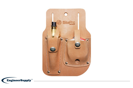
This kit is ideal for those who want to remain organized while on the job. It houses Gammon Reels and Plumb Bobs in a quality leather sheath. The Gammon Reel can be easily worked from the palm, with an internal steel clock spring to help reload the string back into the housing unit once you are finished with it. The 16-ounce plumb bob uses ASA thread and has a hardened steel screw cap for durability. The sheath is heavy-duty leather and stitched using extremely durable nylon thread.
This all-steel construction wheel makes it easy for surveyors to navigate across rough terrain. This unit weighs just over five pounds and can expand to just under four feet. The three-foot circumference spoke wheel and extra wide rubber tire preserves accuracy along uneven or coarse terrain. It allows for efficient measuring in applications such as:
- Large commercial operations
- Heavy construction
- Land surveying
- Utilities
- Landscaping
- Law enforcement
This handle is easy to grip and it can collapse after use for convenient storage. The counter is a five-digit ratchet unit.
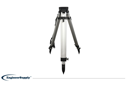
Surveyors require equipment capable of providing extreme precision, and this equipment must also be extremely durable and capable of handling exposure to harsh elements on a job site. This tripod is made from aluminum and has its metal hardware powder coated for wear resistance. Thanks to the poly-webbing shoulder strap and medium, lightweight construction, it is portable. Stability is found in the quick clamp and the wing screw, keeping the mounted equipment stable and secure during use.
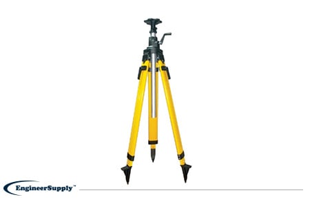
Another mounting option for a surveyor’s equipment is this tripod constructed from fiberglass. It can reach up to 93 inches when extended but collapses to 48 inches for convenient transport and stowing. Stability is achieved through double banded extension legs and the oversized locking quick clamp. A center column contains a metal gear and rack system to give the mounted equipment smooth, continuous motion. It’s powder-coated for extra durability, and its hardened steel shoe points can be replaced as needed.
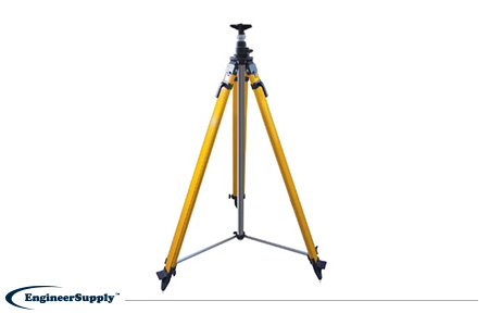
This heavy-duty elevator tripod is essential for the professional surveyor. This stability and durability improve the accuracy of the results, and the increase in extension allows for more diverse applications. There is a detachable aluminum round head and stud to give a GPS antenna more stability, and the engineered polymer shoes create a secure hold to the ground. Like other units, this tripod has dual clamps, powder coating and a gear and rack system for continuous motion. At 33 pounds, this is a heavier unit but still able to be carried easily with a handle grip and leg strap.
Get the Job Done Right
A professional land surveyor is a way to ensure your surveys are accurate and meet the requirements of your project. For any
SitePro tools or equipment needed for the project, Engineer Supply is the place to shop. The wide
selection of tools and site accessories from industry-leading names will ensure your job is done right. Place your order today.

Frequently Asked Questions
What Kind of Training Does a Land Surveyor Need?
The requirements for training depend on the state where the surveyor works. For many locations, there is a minimum education requirement of a bachelor’s degree in either surveying, mapping or a related field.
Can I Purchase Surveying Equipment and Conduct the Research on My Own?

Although anyone could purchase surveying equipment, for property boundaries and other elements to be officially recorded, the work must be done by a licensed surveyor. Architects, contractors and developers will usually require the work from a licensed professional as well.
How Do I Know What Kind of Survey Is Needed for My Project?
When purchasing a piece of real estate, you will likely need to determine your property boundaries. This is done through a survey, but you can extend the reporting to include a topographical survey and utility locating. Your development company or architect can specify which information is needed to proceed.
How Are Surveys Recorded?
Each county will have an office records office where a record is made of the survey conducted. Most often, a map shows the deed lines for a parcel of land through either the property lines or the physical land boundaries.
Does My Survey Become Public Record?
In some cases, any properties that have been mapped using a geographic information system or mapped for boundary lines can be accessed by the public. Specific surveys unique to your project may remain on record with all parties who have an interest in the site, such as contractors or utility companies.
Best Survey Equipment
Magnetic Locators
If you’re looking for lot lines in an urban or suburban area, there are likely already surveying stakes in the corners of every lot. It’s important to mark your own lines to verify accuracy, but a convenient place to start is with the existing surveying stakes.
A magnetic locator helps you find these stakes. Simply turn on the locator and work your way around the area where a stake is likely buried. These locators detect magnetic signals from buried metal items, so they’ll find a number of other items in addition to surveying stakes. Once you find a metallic object, dig it out to verify it’s a stake.
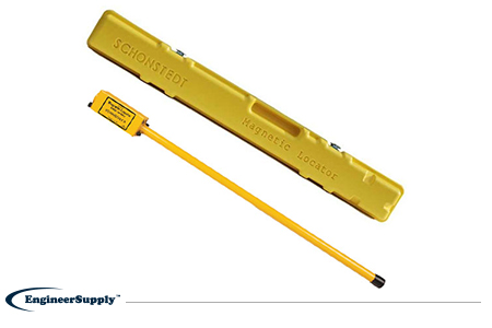
One of the most convenient, practical locators is the
Schonstedt GA-52Cx. This basic model is highly reliable, but doesn’t have all the programmable settings of other locators. Use it to find metallic objects with highly sensitive location technology and a rugged, weather-resistant control panel.
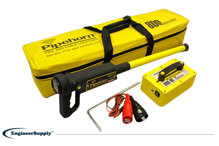
The
Pipehorn 800HL detector is one of the most versatile options for locating buried objects. This dual-frequency detector works as both a pipe and cable locator. Connect the transmitter to a buried line to follow an electric, water or gas line buried in the ground. Once you locate and flag these buried lines, switch modes to sweep for unmarked utilities with the tracer wire and tape.
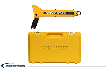
A more portable, high-tech Schonstedt magnetic locator option is the
GA-92XTd. This model uses a compact design and versatile control panel for both audio and visual indication. The small size doesn’t mean less power, so you can use this locator to find ferrous items buried up to 16 feet underground. Pack it away in the small, durable case to keep in your truck or toolbag wherever you work.
Please Wait...

