SPH Engineering - EngineerSupply

SPH Engineering

SPH Engineering is a technology company specializing in geophysical and surveying solutions. One of their key offerings is a terrestrial Ground Penetrating Radar (GPR) system designed for efficient subsurface exploration. This system enables users to detect and map underground structures, utilities, and anomalies in various terrains. Known for its user-friendly software integration and high-resolution data output, SPH Engineering’s terrestrial GPR is utilized in fields such as archaeology, construction, and environmental monitoring.

SPH Engineering

3D Terrain Awareness

3D Terrain Awareness.

Export-Friendly

Export-Friendly.

Multiple Sensors

Multiple Sensors.

Cloud Data Sync

Cloud Data Sync.

Modular System

Modular System.

Helpful Videos

Watch and Learn our videos

How to Set Up the Zond Aero 500 NG GPR for Easy Ground Surveys


Setting up the Zond Aero 500 NG Ground Penetrating Radar (GPR) for ground surveys is much easier than you might think. In this setup, we’re using a simple cart to make things mobile and smooth when working on different sites. This GPR model is built to help you find small utilities and underground objects without the hassle. It’s not just for drones — it works really well for people walking the site too. The shielded antenna helps block unwanted signals so you can get clean and clear data fast. This tool is a great fit for jobs in construction, utility mapping, and geophysics. It saves time, gives you real answers, and helps you see what’s under your feet.


Zond Aero 500 GPR: Smarter Ground Surveys with Drones


The Zond Aero 500 Ground Penetrating Radar makes underground surveys faster, safer, and a lot easier. It works with drones, so you don’t need to waste time or risk safety in hard-to-reach areas. This setup helps you spot buried pipes, structures, and even geological layers with clear and accurate results. It’s quick to set up and covers big areas fast, which saves you both time and effort. Whether you work in construction, archaeology, or mapping utilities, this tool gives you reliable answers without the headache of old methods. You can get in and out of a site quicker, gather the data you need, and move on to your next project with confidence.


Featured Articles

Read our Helpful Articles

SPH Engineering

How SPH Engineering Began

SPH Engineering Company began in 2013 with a simple but smart idea—drones are just flying computers that need good software to do amazing things. Back then, drone technology was expensive and difficult to use, so building a tool like UgCS for flight planning was a considerable challenge. But the team stuck with it. After testing, tweaking, and extensive learning, UgCS has become one of the top tools for drone pilots. Over the years, they have added new systems, such as drone light shows and tools that enable drones to work with sensors for tasks in mapping, surveying, and more. One particularly ambitious project even involved searching for a lost World War II plane in Greenland. Today, SPH operates from Latvia and assists people in over 150 countries in performing smart work with drones..


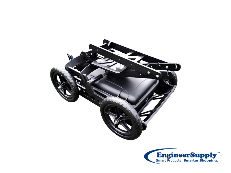
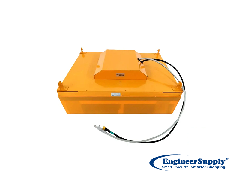
Zond Aero 500 NG: Made for Field Pros

They built the SPH Engineering Zond Aero 500 NG GPR Terrestrial System for serious ground scanning. It comes with a 500MHz shielded antenna, Wi-Fi, and a built-in battery, all housed in a tough transport case, making it easy to use in the field. Whether you're working on a road, airport, rail line, or historical site, this system helps you spot what's hidden below—fast and clearly. It can scan up to 4 meters deep and handles high-speed data collection with options for thousands of samples per scan. You can push it on a cart, pull it with a rope, or mount it on a drone. It's smart, strong, and ready for action wherever your survey takes you.


SPH Engineering

Frequently Asked Questions

Can SPH Engineering software plan flights in 3D terrain?

Yes! UgCS adjusts flights based on the terrain, helping avoid crashes and keeping data accurate.

What does UgCS stand for?

UgCS means “Universal ground Control Software.” It’s SPH’s flight planning software for drones.

What makes SPH’s GPR system better than others?

It’s lightweight, easy to use, gives clear data, and works both on the ground and in the air. Plus, it comes in a rugged, all-in-one case.

Does SPH Engineering offer custom development?

Yes, if you need something special, SPH Engineering products can build custom software or integration solutions for your project.

Is SPH’s software updated regularly?

Yes, they release updates often to add new features, support more drones, and improve performance.

What kind of sensors can I connect to SPH’s systems?

GPR, LiDAR, magnetometers, echo sounders, gas detectors—you name it. Their SkyHub makes the connection easy.

Customer Reviews

  • 5 Stars
    Quick service, exactly what we ordered. Have ordered two more.
  • 5 Stars
    went very well
  • 5 Stars
    Great prices. Fast delivery.
Please Wait... processing