 Ground-penetrating radar, or GPR for short, is a simple and reliable technology for gathering the data needed to map Earth’s subsurface and pinpoint utilities’ underground positions. Because it is safe and quick, detects conductive and non-conductive materials and doesn’t require digging, GPR is a popular technology among professionals.
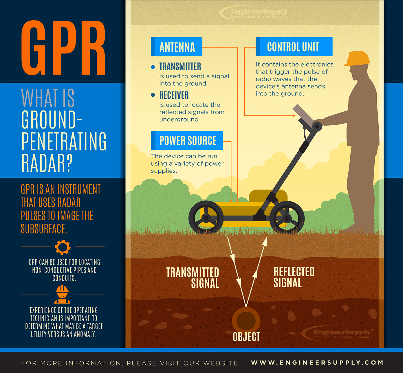
How It Works
A GPR utility locator has three parts (the powers source, control unit and antenna) and relies on high-frequency radio waves to function. The following are the four basic steps of a GPR device’s operation:
- First, the control unit sends a burst of electricity to the antenna (Each GPR device has at least one.).
- Next, the antenna magnifies the electrical signal and sends radio waves underground. The antenna’s frequency will determine how deep the waves can travel.
- After that, the waves travel underground, and some of those waves are reflected back to the antenna and the control unit, where they are kept.
- Finally, the information is processed and analyzed before being shown as images on the control unit’s screen. At this point, it’s possible to learn details about the underground utilities, including their location, depth and size.
GPR in Utility Locators
When you see an underground utility locator, GPR is likely used in it because it’s able to find numerous objects, including septic tanks, telecom wires, voids, water boxes and different kinds of pipes. While GPR is unable to determine the exact substances the objects are made from, the images do show areas where there are contrasting compositions, indicating that an underground utility is present.
Choosing an antenna with an appropriate frequency is key to finding utilities beneath Earth’s surface. The ideal frequency is generally 500 megahertz, unless you’re searching for utilities within floors and walls, in which case you’ll need a 1,000-megahertz antenna. Concrete and other similar materials require higher frequency antennae.
Maximum Depths
The waves from GPR can travel up to 100 feet deep. For materials with higher levels of conductivity, like shale, the waves will reach a maximum depth of about three feet. This is because those materials will quickly absorb the waves. On the other hand, matter with lower levels of conductivity, like granite or sand, won’t absorb the waves as quickly, allowing them to descend as much as 100 feet underground.
Magnetic Locators
Magnetic Locators are another type of utility locator used for locating land survey markers, ductile iron water lines, and survey monuments. Also known as "Locating Wands", Magnetic Locators, set the standard for reliability and dependability they locate metal that has ferrous in it such as steel, rebar, and iron. If a magnet can stick to it, it has ferrous material, hence the name "Magnetic Locator". The level at which you can locate an object using an underground utility locator is determined by the mass of the object you wanting to locate. The larger the object, the more magnetized field it puts out and hence easier to detect.
Order Yours Today
If you’re searching for a GPR system, shop EngineerSupply, a trusted site for architecture, engineering and construction equipment for 20 years. You’ll find the highest quality products at affordable prices, and we’ll provide personalized service that puts you first. Call 800-591-8907 or visit our website to place your order today.