Equipment used for surveying

3 Pieces of Equipment Commonly Used for Surveying
The surveying industry helps property owners, developers, investors, city governments and a range of other organizations determine the details of a specific plot of land or area. A survey can be used to determine boundary lines, landforms or potential complications concerning the stability of the property development. Because the information provided is so important to the safety and legal needs of property owners, the surveying equipment needs to be extremely precise.
Survey tools have changed a lot over the years, but they are accurate and specific.
3 Common Survey Instruments
Over the last several years, technology has improved the way surveying is done. The instruments obtain accurate measurements that are used for modeling, mapping or creating property or floor plans. There are other uses for the instruments that don’t involve surveying, since they work equally well for gathering measurements. These are three of the most common pieces of equipment used for surveys.
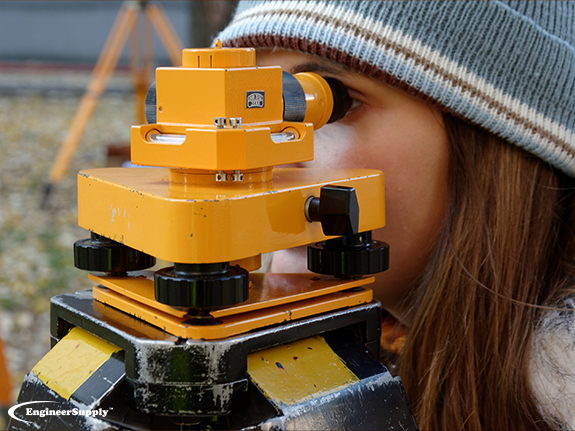
Theodolite
The earliest theodolite to make an appearance in the United States was used for the United States Coast Survey back in 1815, but history dates this piece of equipment back to the 1500s. Significantly more advanced on account of technology, theodolites are used today for accurately measuring angles in both vertical and horizontal planes. It’s primarily used for a topographic survey.
A total station theodolite is more commonly used than a theodolite because it combines the measuring capabilities of the equipment with an electronic distance measurement and a microprocessor to store the data. It can read slope distances making it useful for surveying in mines or quarries, but it’s also used for evaluation surveying, setting out or topographic projects. The measurements rely on an infrared carrier signal generated by an emitter in the optical path of the instrument. The signal is reflected by a prism reflector on the point, with the pattern of the return signal being read, recorded and interpreted using the microprocessor.
The total station improves upon the horizontal and vertical measurements of a theodolite by calculating the distance between two points, taking an average of multiple distances or angles measured and taking elevation measurements. Because of the ability to remotely measure points, total stations can accurately measure the heights of structures or buildings from a distance.
Drones
One of the more technologically advanced pieces of
survey equipment is the drone. Because of the impressive range and visibility from up above, these surveys are used for large areas or places where it would be difficult to take other equipment. Drones also provide a photographic record, making it ideal for printing and producing images with compatible software. Point cloud information is also an option from drone surveying, which can complement terrestrial laser scanning.
Transit Level
The last of the more common
survey tools is the transit level. Despite its relative simplicity, it’s still highly useful in measuring relative levels along horizontal lines and points. This equipment is so precise is can measure to the tenths of millimeters, showing extreme accuracy in tracking infinitesimal movement over time.
To purchase your own
survey tools,
shop the selection at Engineer Supply. We carry a large selection of equipment from industry-leading manufacturers. Order yours today.

Frequently Asked Questions
Do I Need My Equipment Professional Services?
To preserve the reliability of your instruments, it’s recommended that total stations and other sensitive pieces be taken to a service center at least once a year for a thorough tune-up and preventative maintenance.
Should My Equipment Be Calibrated Before Each Use?
Upkeep your equipment in the field by calibrating a total station at least every two weeks. It’s also important to check the accuracy of your machines against control points before conducting a survey, whether it’s a total station or GPS receiver.
How Often Do Software Upgrades Take Place?
It’s routine for a manufacturer to release several software updates throughout the year, as the updates are designed to correct any bugs found in previous updates and to improve reliability in performance. Paying extra for software support improves the accuracy of your machines.
What’s the Best Way To Transport My Equipment?
Even though surveying equipment is designed with rugged environments and exposure to elements in mind, carrying and storing your equipment in the protective case it comes in the cab of your truck is the most effective way to protect your equipment. These are precision devices and should be treated that way.
Should I Clean My Equipment?
The conditions where you use your equipment will expose it to dust, dirt and other substances. All you need for cleaning is a gentle soap and water. Don’t submerge the equipment. Use a lens cleaning cloth for the lens or alcohol wipes on the device.
Best Survey Equipment
Magnetic Locators
If you’re looking for lot lines in an urban or suburban area, there are likely already surveying stakes in the corners of every lot. It’s important to mark your own lines to verify accuracy, but a convenient place to start is with the existing surveying stakes.
A magnetic locator helps you find these stakes. Simply turn on the locator and work your way around the area where a stake is likely buried. These locators detect magnetic signals from buried metal items, so they’ll find a number of other items in addition to surveying stakes. Once you find a metallic object, dig it out to verify it’s a stake.
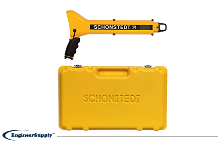
One of the most convenient, practical locators is the
Schonstedt GA-52Cx. This basic model is highly reliable, but doesn’t have all the programmable settings of other locators. Use it to find metallic objects with highly sensitive location technology and a rugged, weather-resistant control panel.
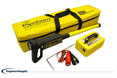
The
Pipehorn 800HL detector is one of the most versatile options for locating buried objects. This dual-frequency detector works as both a pipe and cable locator. Connect the transmitter to a buried line to follow an electric, water or gas line buried in the ground. Once you locate and flag these buried lines, switch modes to sweep for unmarked utilities with the tracer wire and tape.
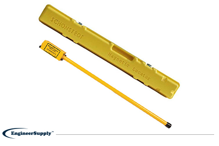
A more portable, high-tech Schonstedt magnetic locator option is the
GA-92XTd. This model uses a compact design and versatile control panel for both audio and visual indication. The small size doesn’t mean less power, so you can use this locator to find ferrous items buried up to 16 feet underground. Pack it away in the small, durable case to keep in your truck or toolbag wherever you work.