It can be useful to refer to map and satellite views of a parcel of land before starting a survey. Note any landmarks or roads that you can use as waypoints to check manual measurements.
Some applications estimate distances or calculate area based on existing maps. This data may not be as accurate as the measurements you take during an informal walking survey or obtain through an official
Manually Input Landmarks Into the App

The landmarks you place during a survey serve as points of reference. Most mapping apps enable users to drop different types of pins or color-code input based on the type of data you are recording.
In addition to measuring distances between points, you can also reference the GPS coordinates of landmarks to check the accuracy of a survey. Dropping points is also useful for segmenting measurements and accounting for complex layouts.
Map Out and Measure Newer Roads
During a survey, you can locate and measure the length of new roads that do not appear on existing maps or in satellite images. Use the record and stop options in a survey app to map out and track the distance of any route.
Based on the purpose of a survey, you may prefer to start a separate project to measure roads. You can also mark a road as a landmark in a general survey.
Look Over Topographical Maps Before a Survey

A topographic map is a detailed quantitative representation of contours and relief features. Some survey apps measure elevation, but it is useful to have access to topographical maps based on a standard geodetic framework.
Check a topographical map in advance of a walking survey to determine the best starting point and plot outlines. Check to see if the features of a survey app account for topographic data.
Save Coordinates From Official Property Markers
Official property markers provide established landmarks and coordinates for reference in an informal survey. Save these coordinates to find locations in the field.
Make sure the app you use to
survey land can account for official property markers and landmarks. The ability to create new landmarks is also useful when conducting a survey.
Smartphones Can Be Valuable Surveying Tools
A smartphone with a compass and GPS receiver has all of the tools you need to take approximate measurements of land. Given that the average cost of a formal survey of land is $500, a free or paid surveying app can be an affordable alternative.
When you need exact measurements for the purpose of confirming the measurements of a parcel prior to purchase or when finalizing the sale of a property, it is worthwhile to invest in an official survey. Even when amateurs use dedicated
survey equipment, independent results are often less accurate than official measurements.
If you have access to a late-model smartphone, you have everything you need to take approximate measurements for an informal survey. Download a highly rated mapping application compatible with a device and perform any necessary calibration measures to take the most accurate measurements possible with a smartphone.
Frequently Asked Questions
How Accurate Are the Compass and GPS Receiver On a Smartphone?

A GPS-enabled smartphone is typically accurate to within a 4.9 meter (16 foot) radius under open sky. The GPS technology in your smartphone may be less accurate for surveys near buildings, bridges or trees. You should calibrate the internal compass if GPS tracking on your phone is less accurate.
What Are the Best Surveying Apps for My Smartphone?
Many free and paid surveying applications are available for Android or iOS smartphones. Search for land surveying apps in the Google Play Store or Apple App Store and look for highly rated apps that have many reviews. The popular GPS Fields Area Measure app is available for Android and iOS.
What Are Some Other Surveying Tools I Can Use?
You can use a distance measuring wheel or laser distance meter to take more accurate measurements. Smartphone measurements based on GPS are much less accurate than measuring wheels accurate to within 3 inches per 100 feet or laser measurers that are accurate to within ⅛ inch or 1/16 inch.
How Long Does Surveying Land Take?
The duration of a survey depends on the method. You can calculate informal measurements based on satellite imagery in a few minutes using an app that has this feature. If you plan to measure land by walking with a smartphone or surveying tools, the distance will determine the survey duration.
You can bring your own device to do casual land surveys. Whether you choose to use a GPS-enabled smartphone or
surveying equipment such as a measuring wheel, measuring tape or a laser distance meter, you can obtain relatively accurate measurements with any of these tools or devices.
Best Survey Equipment
Magnetic Locators
If you’re looking for lot lines in an urban or suburban area, there are likely already surveying stakes in the corners of every lot. It’s important to mark your own lines to verify accuracy, but a convenient place to start is with the existing surveying stakes.
A magnetic locator helps you find these stakes. Simply turn on the locator and work your way around the area where a stake is likely buried. These locators detect magnetic signals from buried metal items, so they’ll find a number of other items in addition to surveying stakes. Once you find a metallic object, dig it out to verify it’s a stake.
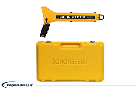
One of the most convenient, practical locators is the
Schonstedt GA-52Cx. This basic model is highly reliable, but doesn’t have all the programmable settings of other locators. Use it to find metallic objects with highly sensitive location technology and a rugged, weather-resistant control panel.
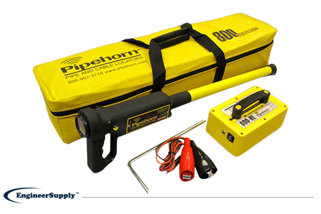
The
Pipehorn 800HL detector is one of the most versatile options for locating buried objects. This dual-frequency detector works as both a pipe and cable locator. Connect the transmitter to a buried line to follow an electric, water or gas line buried in the ground. Once you locate and flag these buried lines, switch modes to sweep for unmarked utilities with the tracer wire and tape.
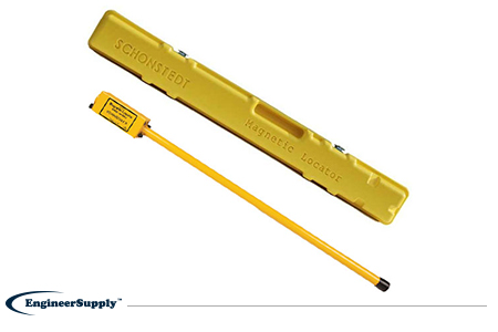
A more portable, high-tech Schonstedt magnetic locator option is the
GA-92XTd. This model uses a compact design and versatile control panel for both audio and visual indication. The small size doesn’t mean less power, so you can use this locator to find ferrous items buried up to 16 feet underground. Pack it away in the small, durable case to keep in your truck or toolbag wherever you work.