Surveying Instruments for Angle and Elevation Measurements

Top 5 Elevation and Angle Measurement Instruments Surveyors Need
There are many different property features that a surveyor must measure — distances, topographic traits, and boundaries are just a few. Sometimes, though, a surveyor must also measure the elevation of a property or determine the angles of its features. In these cases, special
survey equipment is required to capture the required data. The following five selections are some of the best tools for completing these tasks.

1. Hand Level
Hand levels are an important tool for measuring both slope and elevation during a survey. They are one of the simplest
survey instruments to use, and as the name implies, they can simply be held and balanced in order to generate a measurement. The data comes from the spirit level that is contained in the tool, which will ensure that chains are level when measuring a horizontal distance.
2. Abney Level
An Abney level is similar to a hand level, and it, too, can be used for both slopes and elevation. It is slightly more sophisticated than a traditional hand level, though, thanks to its inclusion of features such as a direct reading scale, magnifier, stadia hairs, and improved optics. These features allow for more precise measurements and more exact calculations of slopes. When measuring distance or elevation, the stadia hairs are helpful for ensuring accuracy.
3. Laser Level
The introduction of laser levels was one of the greatest advancements in the field of surveying. This tool is an indispensable resource for quickly and accurately measuring vertical, horizontal, and diagonal distances. It can also be used to measure a slope or an elevation, and best of all, a surveyor needs no assistance to gather these measurements. Laser levels can be either rotating or nonrotating. Rotating models generate a circular beam with a 360-degree reach.
4. Dumpy Level
Surveyors who prefer to use their equipment with a tripod will appreciate the dumpy level. The level can be affixed to a tripod, which offers support and also increases its accuracy. The device itself includes a built-in telescope as well as a spirit level, both of which work in conjunction with the leveling plate to measure a given distance. The platform which holds the spirit level and telescope must be manually leveled prior to this point.
5. Theodolite
Theodolites are sometimes considered outdated equipment, but they are still one of the most essential
measuring elevation tools. Theodolites can be used to measure angles — both vertical and horizontal — and they can also be used to calculate slope or elevation, too. Theodolites rely on an internal telescope that is mounted on two intersecting axes. When this telescope is positioned toward the target object, it produces an incredibly accurate measurement.
Get the Best Measuring Elevation Tools
Measuring elevation and slope is important in nearly every sector of surveying. Ensuring that those measurements are accurate is even more important. The aforementioned five tools make it easy to generate the data you need for your next surveying job. You can find these and other
essential surveying tools at Engineer Supply. If you have questions about any of our products, call us at (800) 591-8907.

Frequently Asked Questions
Why do surveyors need to measure elevation?
There are many reasons why a surveyor may need to measure the elevation of a surface. One of the most common uses for elevation measurement is determining whether or not a foundation or slab has heaved or settled. If so, this could be a major problem that demands repairs.
What is the best tool for measuring elevation?
Surveyors often use several different measuring elevation tools, but levels are the most common equipment for the job. Levels are ideal for this task because they are simple to operate and generate reliable data.
How can surveyors measure slope from a distance?
There are an array of methods a surveyor may use to measure slope, but if the measurement must be captured from a distance, they may use a laser level. A laser level can project its beam from far away, so it’s one of the best tools for this task.
What kind of level is the most accurate?
Any level that a surveyor uses should offer accurate measurements, but some levels may be more precise. A laser level, for example, is often considered one of the most accurate options because its laser beam is easy to see and interpret.
How do surveyors record slope and elevation measurements?
Surveyors need specialized survey equipment in order to measure slope and elevation. Once they’ve gathered this data, it can be recorded by microprocessors that are stored in the equipment, or it can be recorded manually by the surveyor.
Best Survey Equipment
Magnetic Locators
If you’re looking for lot lines in an urban or suburban area, there are likely already surveying stakes in the corners of every lot. It’s important to mark your own lines to verify accuracy, but a convenient place to start is with the existing surveying stakes.
A magnetic locator helps you find these stakes. Simply turn on the locator and work your way around the area where a stake is likely buried. These locators detect magnetic signals from buried metal items, so they’ll find a number of other items in addition to surveying stakes. Once you find a metallic object, dig it out to verify it’s a stake.
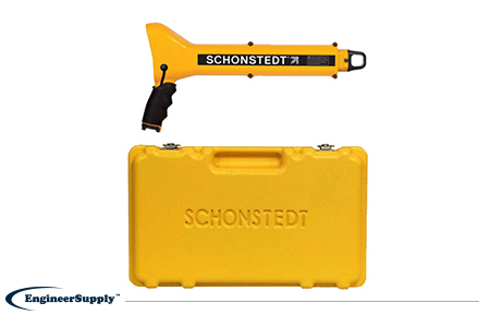
One of the most convenient, practical locators is the
Schonstedt GA-52Cx. This basic model is highly reliable, but doesn’t have all the programmable settings of other locators. Use it to find metallic objects with highly sensitive location technology and a rugged, weather-resistant control panel.
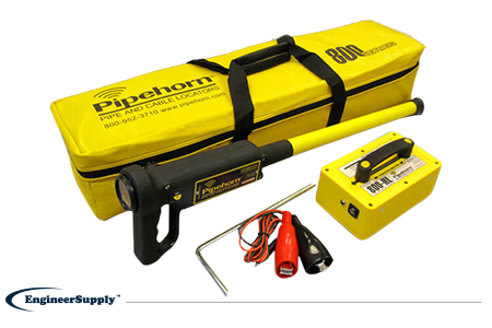
The
Pipehorn 800HL detector is one of the most versatile options for locating buried objects. This dual-frequency detector works as both a pipe and cable locator. Connect the transmitter to a buried line to follow an electric, water or gas line buried in the ground. Once you locate and flag these buried lines, switch modes to sweep for unmarked utilities with the tracer wire and tape.
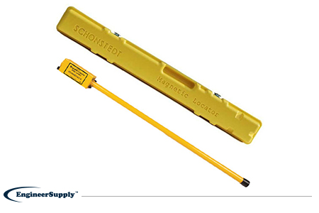
A more portable, high-tech Schonstedt magnetic locator option is the
GA-92XTd. This model uses a compact design and versatile control panel for both audio and visual indication. The small size doesn’t mean less power, so you can use this locator to find ferrous items buried up to 16 feet underground. Pack it away in the small, durable case to keep in your truck or toolbag wherever you work.