What Does a Construction Surveyor Do?

Top 3 Responsibilities of a Construction Surveyor
The construction industry employs about 7.5 million people in the U.S. and generates over $1.5 trillion in revenue. Before a construction project can take shape, though, a construction surveyor must assess the site, take measurements, and produce a report.
Construction surveyors do much more than this, though — in fact, they’re one of the most essential members of any development team. If you’ve ever wondered exactly what a construction surveyor does — and why it’s so important — consider these top three responsibilities of the job.
1. Use the Right Tools
One of the first responsibilities of a construction surveyor is to identify the right tools and use them properly. This might sound like an easy task, but there are countless different
survey instruments to choose from, and selecting the right one requires advanced expertise. A construction surveyor must know, for example, when it’s best to use a transit or a theodolite.
As is true of every other kind of surveying, construction surveying demands an incredible level of precision. Choosing the right
survey equipment is thus imperative. Construction surveyors will choose their equipment based on what kind of measurement they are seeking and what kind of plane they are surveying.

2. Prepare Plats for Development
Construction surveyors also play an important role in preparing plats for development on a new construction site. This means that they must work in conjunction with other members of the team — architects, engineers, and builders, for example — to obtain legal documents concerning the property. The information in these documents will then be used to survey the land and assess the accuracy of previous data.
After this assessment is done, a surveyor will prepare the plat. This word refers to a map outlining the geographic features of a property. This is an essential part of the development process because construction surveyors will identify any items that should be included in the plat, such as boundary locations, adjacent streets, and flood zones. This information will determine the placement of structures and the plan for development that follows.
3. Identify Boundary Lines
Determining the placement of boundary lines is another vital responsibility of a construction surveyor. Many lawsuits and disputes have emerged from contested boundary lines, so it is essential that a construction surveyor accurately identify these features. Construction surveyors typically use tools such as transit levels and total stations to measure the exact dimensions of a piece of property and establish the outline of its boundaries.
This is important to do before breaking ground on a new development because unclear boundary lines can cause a litany of legal issues. It’s also likely to delay the progress of a construction project for weeks, months, or even longer.
Construction Surveyors Need the Right Tools for the Job
Construction surveyors must complete many different tasks as part of their job, and they need many different tools to do so. Finding the right equipment for construction surveys is easy when you shop at Engineer Supply. Our selection of
construction survey tools includes everything you need. Call us at (800) 591-8907 to learn more or place an order.

Frequently Asked Questions
What do construction surveyors do before they survey a property?
Construction surveyors must do research before they complete the survey portion of their tasks. This research is technically considered part of the survey, but it happens before any measurements are taken. The research typically includes reviewing previous surveys and reading legal documents concerning the property.
What kind of tools does a construction surveyor use the most?
Construction surveyors use a variety of tools, including theodolites, total stations, measuring tapes, 3D scanners, and GPS devices. All of these tools are used to gather data about the property and produce an accurate plat.
Why does a construction surveyor need to look at previous surveys?
Construction surveyors will commonly review any surveys that were previously done in order to learn more about the property and determine whether prior assessments were accurate.
Does a construction surveyor help with construction?
Construction surveyors are an important part of development, and they assist with construction by ensuring that building takes place on a safe and stable portion of the property. They typically do not engage in the construction process after building begins, though.
How does a construction surveyor work with developers?
Construction surveyors work closely with developers as a property is being prepared for construction. This process entails assessing the developer’s plans, surveying the property, and creating a plat. The developer will then use the plat to determine the best placement for the structure they want to build.
Best Survey Equipment
Magnetic Locators
If you’re looking for lot lines in an urban or suburban area, there are likely already surveying stakes in the corners of every lot. It’s important to mark your own lines to verify accuracy, but a convenient place to start is with the existing surveying stakes.
A magnetic locator helps you find these stakes. Simply turn on the locator and work your way around the area where a stake is likely buried. These locators detect magnetic signals from buried metal items, so they’ll find a number of other items in addition to surveying stakes. Once you find a metallic object, dig it out to verify it’s a stake.
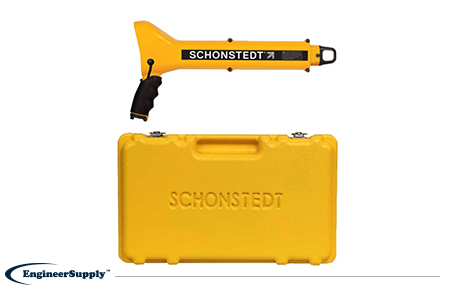
One of the most convenient, practical locators is the
Schonstedt GA-52Cx. This basic model is highly reliable, but doesn’t have all the programmable settings of other locators. Use it to find metallic objects with highly sensitive location technology and a rugged, weather-resistant control panel.
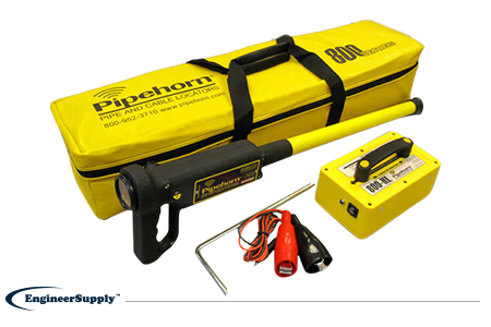
The
Pipehorn 800HL detector is one of the most versatile options for locating buried objects. This dual-frequency detector works as both a pipe and cable locator. Connect the transmitter to a buried line to follow an electric, water or gas line buried in the ground. Once you locate and flag these buried lines, switch modes to sweep for unmarked utilities with the tracer wire and tape.
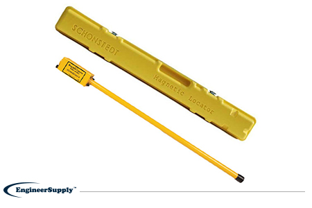
A more portable, high-tech Schonstedt magnetic locator option is the
GA-92XTd. This model uses a compact design and versatile control panel for both audio and visual indication. The small size doesn’t mean less power, so you can use this locator to find ferrous items buried up to 16 feet underground. Pack it away in the small, durable case to keep in your truck or toolbag wherever you work.