Can A Drone Survey Replace A Total Station? | Engineer Supply - EngineerSupply

800.591.8907 M-F 8-5PM EST

21 Years Serving Customers Like You. Buy With Confidence.

Can a drone survey replace the total station?

Blog can a drone survey replace the total station

Surveyors try to “do more with less,” which is why many of them want to figure out how to do aerial surveying with a drone. UAV’s have allowed them to do their job cheaper, faster, and safer — all of which have made them more efficient at what they do. This concept could become increasingly important if the demand for a drone survey increases as time moves forward, and there are a number of reasons to think that it will. Drone technology can allow surveyors to get five times the amount of work done than they could with a total station, and it can reduce the amount of resources needed for a project (including the number of people they need for the job). It’s a luxury that’s quickly becoming a necessity for professional surveyors because they need to keep up with the increasing amount of work in every state.

Advantages of a Drone Survey

A drone survey refers to the use of an unmanned aerial vehicle (UAV) to collect data from the air with the use of downward-facing sensors and LIDAR payloads. With an RGB camera, the ground is photographed several times from different angles. And each image is tagged with a specific set of coordinates. Unlike other survey instruments that are operated on the ground, drones can conduct topographical surveys with the same quality and accuracy but in a fraction of the time. This can reduce the cost of performing a site survey and the workload of people out on the field.

A total station can only measure a specific point. But with a drone survey, you can get thousands of measurements that can be processed into different formats. Some of them include but may not be limited to:

  • Orthomosaic
  • Point cloud
  • DTM
  • DSM
  • Contour lines
Every pixel on the map or point of the 3D model has some type of 3D geo-data. It can also access areas that may not be accessible by other survey instruments. With a drone, you can fly almost anywhere. You’re not limited by areas you can't reach, steep slopes that are too dangerous, or hash terrain that’s not suitable for more traditional measuring tools. You won’t have to close down highways or train tracks. In fact, you can get the data you need without an organizational overhaul.

Blog can a drone survey replace the total stationWith 3D mapping software, you can get volumetric measurements from the same images. It’s a fast and inexpensive way of getting this kind of information, which is useful for calculating stocks in mines and quarries for inventory or monitoring. Surveyors can also capture more topographic data points, which will allow them to get more accurate volume measurements. And they can do it in a much safer way than if they used a total station to capture the data manually. Because a drone survey captures data from above, site operations won’t be interrupted. And the short acquisition time allows you to get a site snapshot at a specific point in time.

With automated GIS analysis, you can get slope measurements from DTM’s and DSM’s that are generated by a drone survey. By knowing the steepness of a ground surface, areas can be classified and used for slope monitoring purposes (including landslide mitigation and prevention). You can also take orthomosaics at different times, which makes it possible to detect changes in earth movement and determine its velocity. This can help with landslide predictions, which can prevent potential damage to roads, railways, and bridges.

Developing urban areas requires a great deal of planning, as well as data collection that can be time-consuming and expensive. But with a drone survey, urban planners can get large amounts of current data in a shorter period of time than with a total station. The images that are produced in this way allow them to look at the existing social and environmental conditions of each site and to evaluate the impact of different scenarios. And because of 3D modeling, buildings can be overlayed onto their environments. This can give planners an experimental perspective of a more complicated development project. 3D modeling also allows them to analyze and visualize the casting of shadows, as well as outlooks and views.

The biggest advantage of aerial surveying is the amount of time you save compared to traditional survey instruments. But until recently, they have been too expensive because it required the use of manned aircraft. By using UAV’s (more commonly referred to as “drones”) have been considered to be a more cost-effective alternative to using a total station. So if you’re ready to take your surveying to a different level, you should consider using it on a job site.

If you’re looking for a broad selection of survey instruments and supplies, be sure to look at what we have at Engineer Supply.

Shop Survey Equipment

Frequently Asked Questions

How does a drone survey work?

Blog can a drone survey replace the total station

UAV’s have allowed surveyors to do more for a lot less because it makes their job cheaper, faster, and safer. With a drone survey, you can get topographic information from above the ground. This allows you to take accurate measurements in a fraction of the time, which can substantially reduce your costs.

How do I process drone survey data?

Survey drones can generate high-resolution orthomosaics and detailed 3D models of areas where low-quality, outdated, or even no data are available. This allows you to create accurate cadastral maps quickly and easily, even in complex or hard-to-reach areas. You can also access certain features from these images, which can include but may not be limited to:
  • Signs
  • Curbs
  • Road markers
  • Fire hydrants
  • Drains
With the same images, you can produce detailed elevation models, contour lines and breaklines, as well as 3D reconstructions of land sites or buildings.

How accurate is a drone survey?

Drones can scan the ground with a great deal of precision. It sends out hundreds of thousands of pulses per second to map topological differences in relation to each other, which allows you to get what you need with an incredible degree of accuracy.

What is meant by drone surveying?

Using drones can give surveyors more opportunities to get what they need quickly. It allows you to conduct topographical surveys of the same quality as you would with a total station or other more traditional survey instruments but in a fraction of the time. This can substantially reduce your operational costs while reducing your workload while out on the field.

How does a drone survey compare to a total station?

Both a drone survey and a total station are excellent tools, but whether one is better than the other depends on the job. If a great deal of detail is needed (such as digital preservation projects on small sites) a laser scanner is the optimal choice. But for more large-scale surveying projects, an RTK-enabled UAV can give you what you need with a great deal of detail and accuracy. It can also be more efficient than more traditional survey instruments.


Best Total Stations

#1: Leica iCON 5-Second iCB70 Manual Construction Total Station

Best total stations leica-868588

Featuring mobile data capability, this Leica total station will let you transfer construction data between the office and the instrument. This will always keep your project progress and plans up to date, which will make sure you don’t miss any changes in the design. The device is simple and easy to master, so you can finish your projects more efficiently and with minimal training. You can analyze layout points both quickly and accurately, even on complex structures. You can also make fast and accurate as-built measurements, do volume calculations on-site, and work with digital design data (including fully rendered models in IFC format).

#2: GeoMax Zoom90 Series Robotic Total Station Package

Best total stations geoMax-6010321

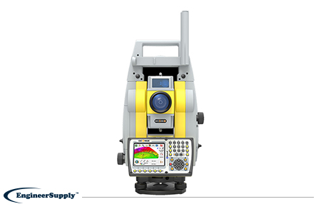
With this total station, you can minimize the amount of time it takes to perform any survey task, while maximizing your performance and accuracy on the job site. This total station for surveying is the ultimate one-man system with the following features:

  • Up to 20% more automation performance.
  • Extended reflectorless measurement capability.
  • STReAM 360.
  • AccXess technologies.
  • Windows CE open connectivity.
It will scan the entire working area in seconds, so you can find your target quickly. Once it’s locked, the instrument will continue to aim at the target (even if it’s moving). It will also aim accurately at any prism without having to look through the telescope, and measurements are performed automatically with a great deal of dependability.

#3: Leica iCON 5-Second iCB50 Manual Construction Total Station

Best total stations leica-868584

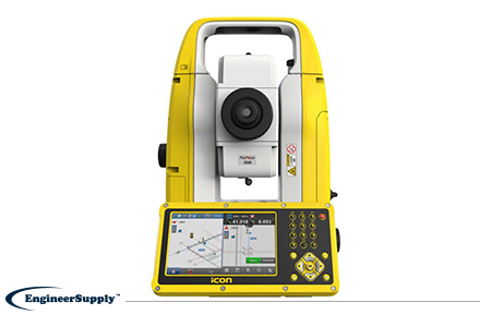
This Leica total station will allow you to go digital, so it’s leading the way to the no-strings and no-tapes approach for a construction project. It’s easy to learn, so you can finish your projects more efficiently and with very little training. This total station will allow you to perform a variety of tasks, which include but may not be limited to:

  • Evaluating layout points and lines quickly and accurately.
  • Evaluating complex structures easily.
  • Quickly performing verticality checks on formwork and structures.
  • Completing fast and accurate as-built measurements.
  • Working with digital design data (including fully rendered models in IFC format).
If you’re looking for one of the best total stations for construction and surveying applications, be sure to pick yours up at Engineer Supply.
Please Wait... processing