Land Surveying Software for Civil Engineering & Construction

Why AutoCAD Is the Best for Land Surveying and Construction
When it comes to
land surveying software, there aren’t very many options that can top AutoCAD — short for automatic computer-aided design. AutoCAD was introduced in 1982 to give users the ability to draft projects and design landscapes. It is now the most popular
land survey software on the market. It’s particularly useful for civil engineers and construction professionals who need to create elaborate drafts of different structures. Learn more about this program and the following five benefits that it can offer to users.
1. Generate 2D and 3D Landscapes
The most basic function of AutoCAD is also one of its greatest benefits. When the program first emerged in the 80s, it revolutionized its field because no other program could do what it did — produce both 2D and 3D models and landscapes. AutoCAD allows users to draft and manipulate 2D drawings or convert those drawings to a 3D model. This versatility makes it easier to create accurate project mock-ups.
2. Collaborate and Draft Projects
AutoCAD’s built-in collaboration tools further allow users to create the designs they envision. Users can send direct links to their drafts so that colleagues and collaborators can view and contribute to projects. The original owner of the file can easily control the editing and viewing access granted to recipients, too, so that security is never compromised. Files can safely be stored in the AutoCAD cloud so that they can be opened and edited at any time.
3. Enjoy Better Data Fidelity
Yet another important benefit of the AutoCAD platform is the top-tier data fidelity that users can enjoy. This is thanks to its use of the proprietary .dwg file extension format. Many other CAD programs have adopted this file format, too, but AutoCAD still maintains the best compatibility and usability for this type of file.
4. Utilize Built-In Workflows
AutoCAD users can shave hours off of the design process by using the platform’s built-in workflow tools. One study even indicates that AutoCAD users were 63% more productive when they used the program’s specialized tools. Users can set their own shortcuts and establish their default workflows so that routine tasks are easy to complete quickly, thus saving time.
5. Automate Simple Drafting Tasks
Automation is another important benefit of the AutoCAD program. In fact, the various automation tools of the AutoCAD platform may make it the
best land surveying software for construction and civil engineering. The program’s AutoLISP feature allows users to code specific tasks for automation. If you want to automatically publish a project on a specific schedule, for example, you can use the AutoLISP feature to automate this task.
Invest in the Best Land Survey Software
AutoCAD is considered the best in its class for many reasons. In addition to pioneering the field of CAD, the program has introduced many features that make it stand apart from competitors. No other
land survey software can match the results. Find the AutoCAD software and
CAD accessories you need at Engineer Supply. Call us at (800) 591-8907 if you have questions about your order.

Frequently Asked Questions
What do you use AutoCAD for?
AutoCAD is most commonly used for designing 2D and 3D renderings of structures and landscapes. This makes it an ideal land survey software, and it also allows professionals such as civil engineers and construction designers to plan their projects in advance.
How much does AutoCAD cost?
AutoCAD is available at different price points, depending on who is buying it. If you are a student, academic institution, or educator, you may be able to get AutoCAD for free through an educational license. Others may need to purchase an annual subscription, which is $1,865, or a monthly subscription, which is $235.
Who makes AutoCAD software?
AutoCAD was developed by Autodesk in 1982, and the brand still maintains and publishes new versions of the software. It is the flagship product of the Autodesk brand, and it is currently available in versions for Windows, Mac, and iOS.
How do land surveyors use AutoCAD?
Land surveyors use AutoCAD in many ways. The program is primarily useful for its ability to accurately represent information relating to a survey site. The 3D modeling feature, for example, allows surveyors to represent the unique topographical features of a site.
Why is AutoCAD better than other CAD programs?
AutoCAD is not the only CAD program on the market, but it’s certainly the most popular and widely considered to be the best. This is because it pioneered the field of CAD and offers more automation and workflow features than most other programs.
Best Survey Equipment
Magnetic Locators
If you’re looking for lot lines in an urban or suburban area, there are likely already surveying stakes in the corners of every lot. It’s important to mark your own lines to verify accuracy, but a convenient place to start is with the existing surveying stakes.
A magnetic locator helps you find these stakes. Simply turn on the locator and work your way around the area where a stake is likely buried. These locators detect magnetic signals from buried metal items, so they’ll find a number of other items in addition to surveying stakes. Once you find a metallic object, dig it out to verify it’s a stake.
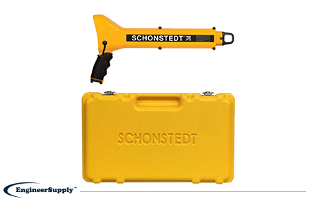
One of the most convenient, practical locators is the
Schonstedt GA-52Cx. This basic model is highly reliable, but doesn’t have all the programmable settings of other locators. Use it to find metallic objects with highly sensitive location technology and a rugged, weather-resistant control panel.
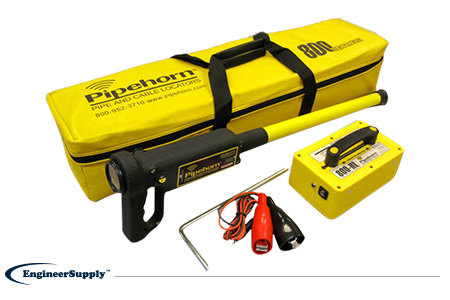
The
Pipehorn 800HL detector is one of the most versatile options for locating buried objects. This dual-frequency detector works as both a pipe and cable locator. Connect the transmitter to a buried line to follow an electric, water or gas line buried in the ground. Once you locate and flag these buried lines, switch modes to sweep for unmarked utilities with the tracer wire and tape.
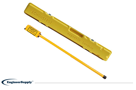
A more portable, high-tech Schonstedt magnetic locator option is the
GA-92XTd. This model uses a compact design and versatile control panel for both audio and visual indication. The small size doesn’t mean less power, so you can use this locator to find ferrous items buried up to 16 feet underground. Pack it away in the small, durable case to keep in your truck or toolbag wherever you work.