How Does Land Surveying Work? The Process and the tools - EngineerSupply

800.591.8907 M-F 8-5PM EST

21 Years Serving Customers Like You. Buy With Confidence.

Land Surveying: The Process and the Tools

Survey Equipment Header

How Does Land Surveying Work?

Have you ever seen someone in a hardhat with a tripod and strange-looking stick standing by the side of a road or property? If so, you probably wondered what that person was doing. Well, wonder no more. That person was most likely a land surveyor, and he or she was probably taking a variety of precise measurements with specialized surveying equipment to determine exactly where property boundary lines were located.

Land surveyors use high-tech equipment and good old-fashioned mathematics to create maps and measurements of land. If you’re wondering why such a service is needed, you may be surprised to find out that almost every property development project begins with a survey. Here’s what you should know about this important service.

Land Surveying Processes

Land surveyors may have slightly different processes, depending on the specific type of surveying they do. Here’s a quick overview of the various land surveyor types and the basic processes they go through to do their jobs:

  • Construction or Engineering: This type of surveyor studies changes in property lines and identifies the location of buildings and roads with exactness. They may also survey road topography and grade or determine the appropriate depth for building foundations.
  • Geodetic: A surveyor who uses satellite and aerial imaging to measure very large portions of the earth is called a geodetic surveyor.
  • Boundary or Land: This type of surveyor fulfills the important duty of determining exactly where properly lines are located.

There are other types as well, but these are some of the most common. Surveyors must stand by their work and are required to produce accurate numbers. Fortunately, land surveyor tools make it easier for these professionals to have a high degree of confidence in their calculations.


Tools Required

Surveyor demand is expected to grow over 10% between 2016 and 2026, according to the Bureau of Labor Statistics. The median annual wage is around $60,000 for surveyors who work for engineering or architectural firms and approximately $70,000 for government contractors. If you’re interested in pursuing this career path, you’ll need to receive appropriate training and education. You’ll also need the right survey instruments, which include a theodolite and a level (sight level, laser level and/or water level). A theodolite is the ultimate surveying tool and measures vertical and horizontal angles between points. Advanced theodolites can also measure distance.


Shop Survey Equipment

Get Started

Finding the right tools to start surveying is easier than you think. Engineer Supply has a wide variety of quality surveyor equipment and supplies. Learn more about how to quickly order what you want online, or call us directly at 800-591-8907.


Land Surveying Frequently Asked Questions

What is a land survey?

Surveyor using Equipment

A land survey is a process that is used to determine the features and boundaries of a property. It can also be used to determine easements, encroachments, to find out how to develop or build on land, as well as to maintain local codes and regulations. There are different types of land surveys that can be performed depending on the need.

What are the types of land survey?

There are 3 major types of land surveys Construction or Engineering, Geodetic & Boundary or Land.

  • Construction or Engineering: studies changes in property lines, the location of buildings, road topography and grade.
  • Geodetic: uses satellite and aerial imaging to measure large portions of the earth.
  • Boundary or Land: determines where properly lines are located.

How long is a land survey good for?

A survey is considered to be good for 10 years because that’s the time by law that a surveyor would be liable for.

What equipment is needed to conduct a survey?

To get started in surveying you need a theodolite and a level (sight level, laser level or water level). A theodolite is considered as the ultimate surveying too. It is used to measure vertical and horizontal angles between points. Having the right survey equipment ensures accurate and reliable results.

Why would you have your property surveyed?

As a property owner you need to understand possible encroachments on your property. A survey identifies where the property lines and corners are so that in case of a dispute you know your exact property dimensions. A land survey also helps you protect your investment since it reveals the exact dimensions of the land and the home the property.

How does land surveying work?

Land surveying can be thought of as the science of taking big measurements. In short it is the use of geometry to measure angles and alignments. Surveyors use survey equipment to gather data can be used to help with construction projects, land development & creating accurate maps.

More Articles on Survey Equipment & the land surveying process


Best Smart Levels

David White LT8-300P 26x Transit Level with Optical Plummet

best smart levels 2021 PI-46-D8871

If you’re looking for the best 
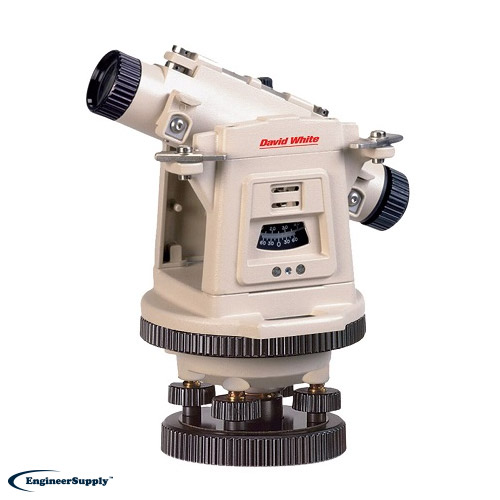
smart level on the market, the David White LT8-300P 26x Transit Level with Optical Plummet is certainly a contender. This unit boasts features such as the following:
  • Range up to 400 ft.
  • Thread size of 5/8 x 11
  • Leveling accuracy of +/- 3/16-in. at 150-ft.
  • Hard carrying case included
This is one of the best builders levels on the market, and its 2 Year manufacturers limited warranty ensures that it will last.

ZIPLEVEL Pro-2000 High Precision Altimeter

best smart levels 2021-PI-ZIPLEVEL-Pro-2000


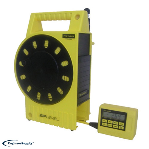
The ZIPLEVEL Pro-2000 High Precision Altimeter is another one of the best builders levels available, with several features that make it stand out:
  • Average, minimum, or maximum record reading
  • Range of up to 12 meter rod or 6 meter tripod
  • Automatic shut off after four minutes to save battery
  • Internal precision of 0.05” and 0.005” in HP
This smart level is designed to measure any elevation or distance, and its rugged build make it perfect for everyday use on job sites.

Topcon 32x Automatic Level AT-B2

best smart levels 2021-PI-2110220B0

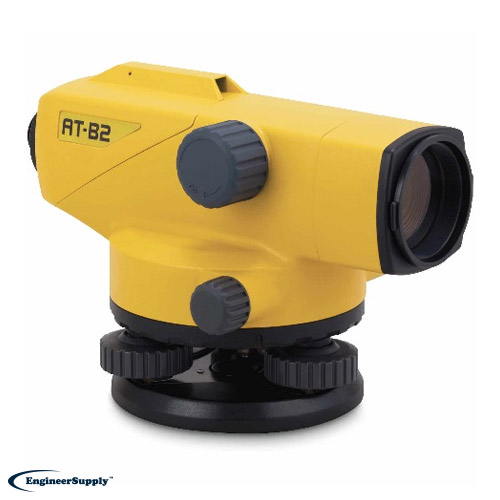
Of all the auto levels on the market, the Topcon 32x Automatic Level AT-B2 stands out for its IPx6 rating and powerful ATB2 viewer. Some of its other features include:

  • 9 inch focusing range
  • +15 arc-minutes range
  • .3 arc-second accuracy
  • 2-speed focusing knob
These details make this one of the most precise levels available. When efficiency and accuracy matter, Topcon gets the job done.

David White LT8-300LP Universal Level-Transit with Laser Plummet

The only thing better than David White builders levels is a builders level that comes with a laser plummet, too. The LT8-300LP is a two-in-one wonder, and offers these features, too:
  • Class 2M laser plummet
  • Thread size of 5/8 x 11
  • Range up to 400 ft.
  • At 150 ft., +3/16 in. accuracy
The unit also includes Stadia and comes with a 2 year manufacturers limited warranty.

Sokkia B20 32X Automatic Level

best smart levels 2021-PI-2110120B0

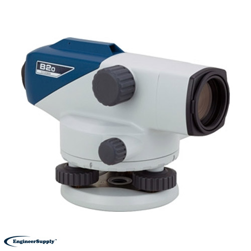
Durability meets precision in the Sokkia B20 32X Automatic Level. With its magnetic damping system and two-speed focus knob, it’s designed for performance. These features add to its appeal:

  • Easy to see stadia lines
  • Quick setup
  • Automatic compensator
  • 20cm focus distance
If you need a unit that’s resistant to dust, shock, and vibration, this is one of the best auto levels you can choose. Its compact design and superior ruggedness is perfect for construction sites.
Please Wait... processing